 ar
ar bg
bg hr
hr cs
cs da
da nl
nl fi
fi fr
fr de
de el
el hi
hi it
it ko
ko no
no pl
pl pt
pt ro
ro ru
ru es
es sv
sv tl
tl iw
iw id
id lv
lv lt
lt sr
sr sk
sk sl
sl uk
uk vi
vi et
et hu
hu th
th tr
tr fa
fa ms
ms hy
hy ka
ka ur
ur bn
bn mn
mn ta
ta kk
kk uz
uz ku
ku
Inclinometer
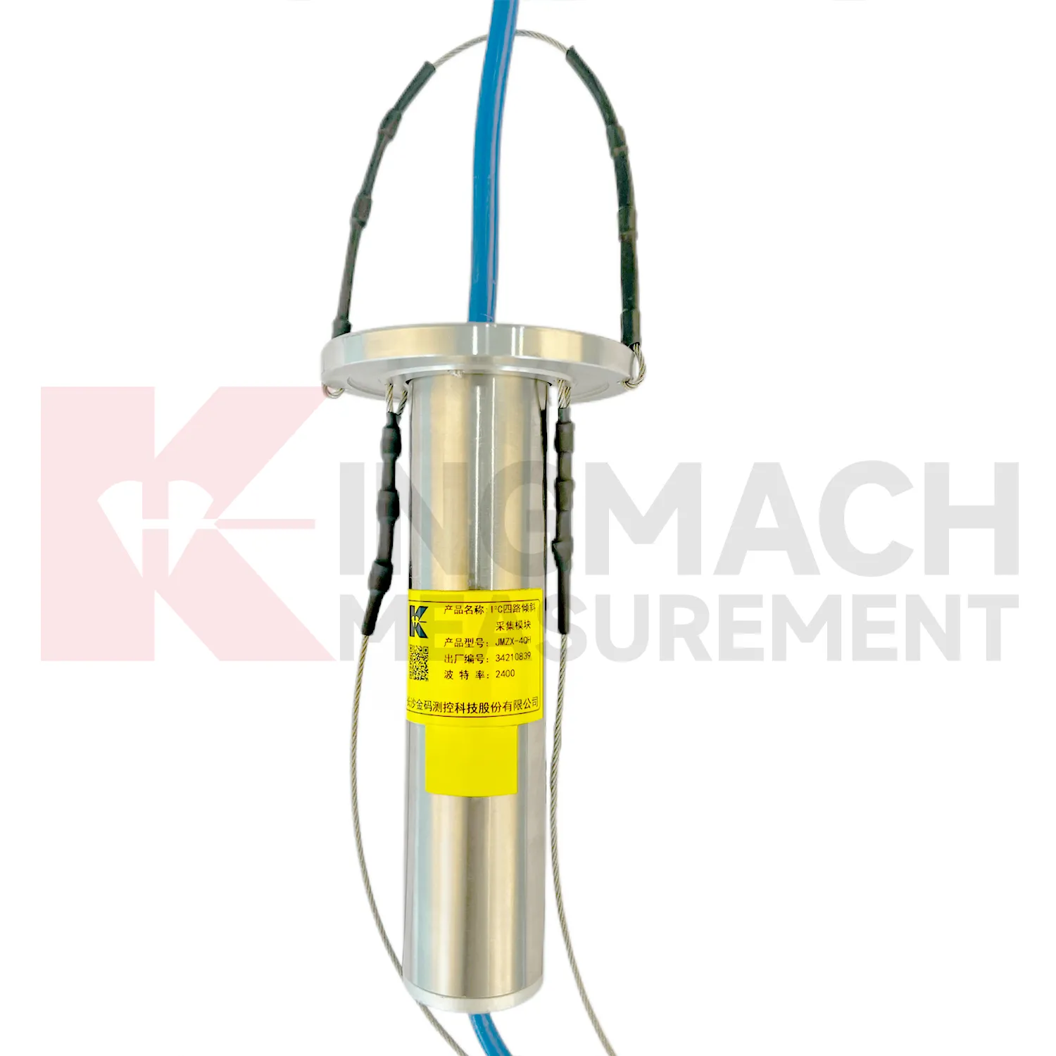
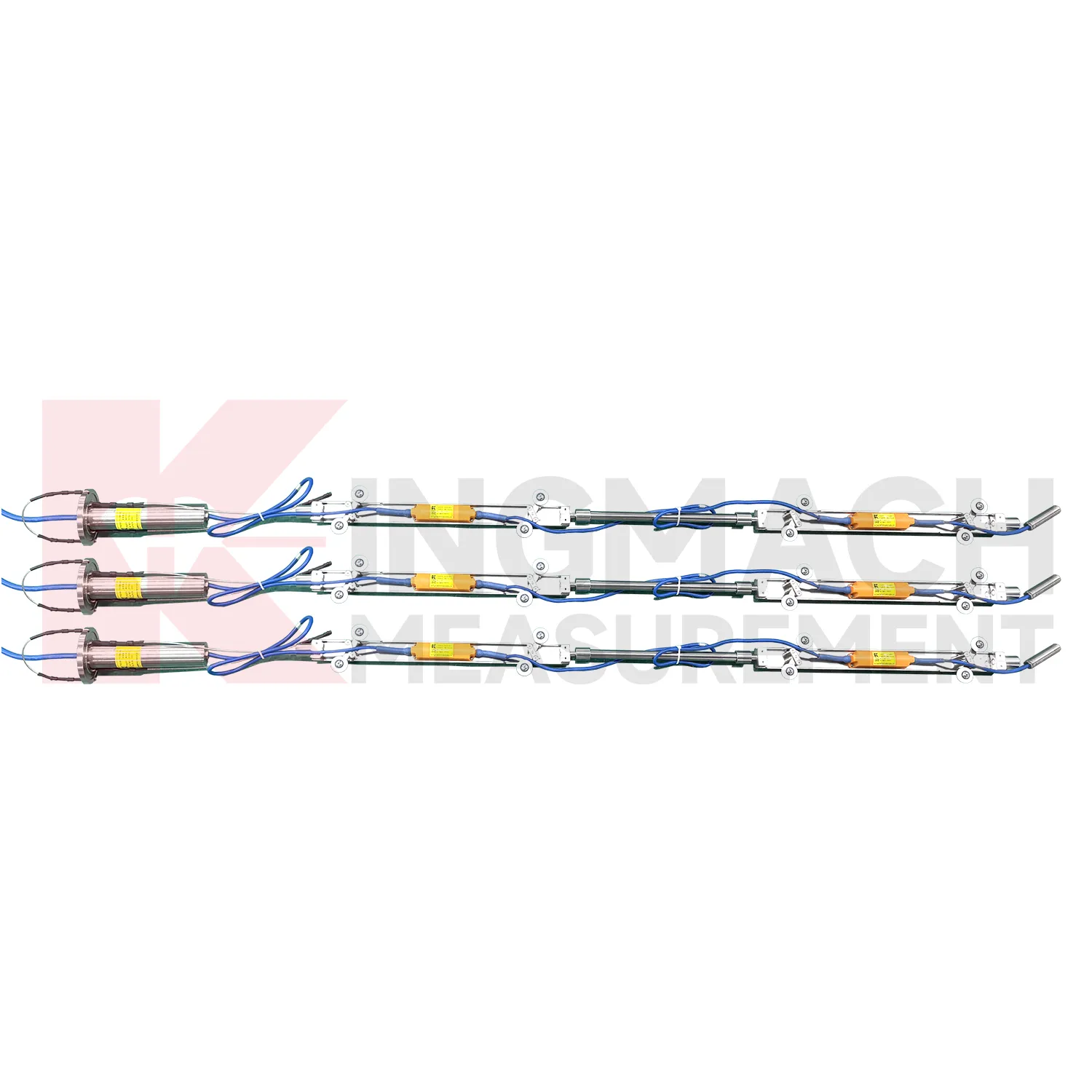
The JMQJ-7915ATS vertical in-place inclinometer system gives Kingmach Inclinometer a multi-point downhole monitoring method. The system consists of a multi-point tandem inclinometer string and an orifice acquisition module. Multiple MEMS inclination sensors are electrically connected through a single cable inside the borehole, while universal joints and connecting rods arrange measuring points according to design spacing. The system can divide sensors into up to four independent communication groups, uses automatic temperature compensation, and includes electronic identifiers for automatic recognition and intelligent calculation. Published specifications include dual-axis +/-90 degrees tilt range, 0.001 degree resolution, 0.01 degree accuracy, DC 9V to 24V operating voltage, power consumption below 0.2W, single-wire uplink communication at 1200 bps, -30 degrees Celsius to +70 degrees Celsius operating temperature, 0.35 m guide wheel spacing, about 0.8 kg weight, and IP68 protection.

Application of Inclinometer
Bridge monitoring uses Inclinometer to observe pier rotation, bearing-area tilt, deck response, and substructure behavior that may not be obvious during visual inspection. A fixed JMQJ-7315ADS can measure biaxial tilt at structural points with 0.001 degree resolution and RS485 output, while JMQJ-7315RTU can transmit tilt data over 4G where cable routing is difficult. Tilt readings should be reviewed with temperature, traffic loading, bearing condition, deflection, strain, and settlement data. A small angular change near one pier has a different meaning from a synchronized response across several supports. The installation record should state axis direction, mounting face, baseline date, communication channel, and nearby structural member. This makes the bridge tilt curve useful for maintenance review, not just alarm display.

The future of Inclinometer
Future Inclinometer will make field commissioning more traceable. Many tilt problems begin with unclear axis direction, unstable mounting, wrong channel naming, poor cable protection, or missing baseline notes. Products with electronic identifiers and digital communication can reduce some of these errors, but field records still matter. Future commissioning tools may guide technicians through axis confirmation, zero reading, communication check, temperature note, photograph capture, and platform channel verification. JMQJ-7315ADS, JMQJ-7315RTU, JMQJ-7915ATS, JMZX-7100L, and JMZX-4QH each need different acceptance steps. A guided process can make the first reading more trustworthy and reduce later debate about whether a curve changed because of the site or the setup.
Care & Maintenance of Inclinometer
Replacement of Inclinometer should preserve measurement continuity. When changing a fixed tiltmeter, integrated wireless unit, in-place string component, acquisition module, or sliding inclinometer accessory, record model, serial number, range, old reading, new reading, reason, date, technician, and any change to axis direction or channel name. Do not hide the replacement by forcing the new curve to look continuous without explanation. If a borehole string is reconfigured, update depth mapping and group communication records. If a wireless unit is replaced, check battery, antenna, and upload timing. A clear replacement record lets future engineers understand the curve and prevents maintenance work from being mistaken for structural deformation.
Kingmach Inclinometer
A well planned Kingmach Inclinometer installation starts with the engineering question, not with the sensor model. Is the project checking bridge pier rotation, building tilt, retaining wall movement, slope depth deformation, railway foundation behavior, or underground construction response? The answer determines whether a fixed biaxial tiltmeter, wireless integrated unit, sliding inclinometer, vertical in-place string, or acquisition module is required. It also determines where the reference direction should be marked, how often readings are taken, and what warning level means. Product parameters such as +/-15 degrees, +/-30 degrees, +/-90 degrees, 0.001 degree resolution, RS485, 4G, Bluetooth, IP68, IP67, and operating temperature should be linked to that project question. Clear planning keeps tilt monitoring useful throughout installation, commissioning, operation, and later review.
FAQ
Q: How should Inclinometer be installed?
A: The mounting surface or borehole position should be stable, the axis direction must be recorded, and the baseline should be saved after the instrument settles.Q: Why is axis direction important?
A: Tilt values only have engineering meaning when the positive and negative directions are tied to the structure, slope, tunnel, or borehole drawing.Q: Can these instruments work in wet sites?
A: Several Kingmach models list IP65, IP67, or IP68 protection, but glands, connectors, cabinets, and cable entries still need field inspection.Q: What should be checked during commissioning?
A: Check model, range, serial number, communication, power, baseline, point name, mounting photo, channel address, and related site condition.Q: Can a tiltmeter be reset after installation?
A: It can be re-baselined when necessary, but the old value, new value, reason, date, and technician should remain visible in the record.
Reviews
Daniel Brown
Excellent environmental monitoring sensors. The data is consistent, and the system integrates smoothly with our existing setup.
David Wilson
We purchased displacement transducers and settlement sensors, and the quality exceeded our expectations. Easy installation and reliable performance.
Latest Inquiries
To protect the privacy of our buyers, only public service email domains like Gmail, Yahoo, and MSN will be displayed. Additionally, only a limited portion of the inquiry content will be shown.
Evelyn***@gmail.comSouth Africa
Hi, we are a contractor working on tunnel construction and need settlement sensors and displacement ...
Sophia***@gmail.comUnited Kingdom
Good day, we need environmental monitoring sensors including temperature, humidity, and wind sensors...